The YHA weren’t lying when they said the Wye Valley hostel was at the end of a “a steep unsurfaced road with a hairpin bend”. The first few hundred metres of the September TT ride was back up that steep driveway more suited to a ‘crosser or MTB. The hostel lies next to the River Wye which was shrouded in mist as I left, but directly above my head was blue sky. I was optimistic about the weather despite the fact I was heading to the Black Mountains in Wales. I’ve been to the Black Mountains quite a few times before for the Green Man Festival, and I’ve only ever not been rained on at one of them. And for two of them it was unbelievably sodden.
Heading west and over the Wye the first climb of the day (the first of many) was over Symonds Yat Rock towards Monmouth via the Forest of Dean. On the long sweeping descent back down towards the Wye at Monmouth I passed over a double border; Gloucestershire into Monmouthshire, England into Wales. At Monmouth I stopped for breakfast and to check my route notes against the map.
 After a pot of tea and bacon sarnie I continued west towards Abergavenny on narrow lanes that rose and fell with regularity. In the distance I could see the Black Mountains, the edge facing me looking like the escarpment edge of the South Downs, but far more menacing. Not helped by the fact the mountain peaks beyond did indeed look black. In contrast the landscape around me was lush green (all that rain) and empty fields the hue of burnt sienna oil paint. Passing a farmhouse a couple of dogs snapped and barked at my cleats, patriotic hounds that could smell English blood?
 Looping back and forth over the A40 and over a hill I was soon passing through Abergavenny and on my way to Crickhowell, crossing another double border into Powys and the Brecon Beacons National Park. Across the River Usk at Crickhowell I passed the Glanusk Estate, home to the Green Man Festival, and towards the first proper hills of the day: The Black Mountains.

The Black Mountains are the eastern most edge of the Brecon Beacons, a set of ridges separated from the rest of the Beacons by the Wye Valley and straddling the border of Wales and England. These lumps of sedimentary rock – sandstones, mudstones, siltstones – were to be my playground for the next couple of hours.
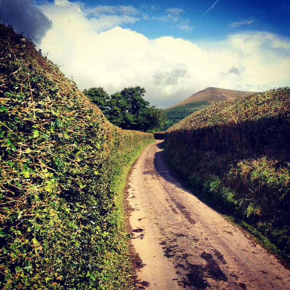
 After passing back over the River Usk and then the A40 I started the climb towards the pass between Mynydd Llangorse and Mynydd Troed. I headed towards the town of Llangors before turning onto a narrow lane lined with high hedges, framing Mynydd Troed ahead of me.
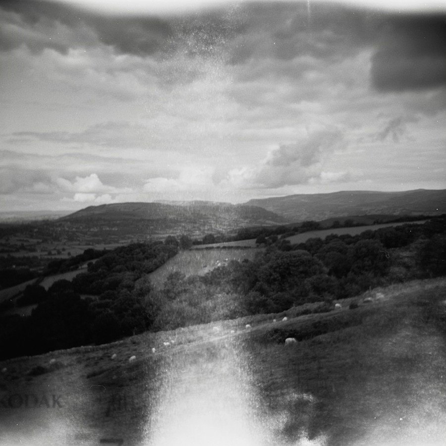
 The lane got narrower and steeper, the pain in my legs greater with each pedal stroke. Then rounding a corner I was at top. I glanced behind me and then had to stop to take in the vista. Down below was Langors Lake and the Brecon Beacons rising into the distance. The last mile or so had hurt but the tops of hills are fine places to arrive at.

 The view to the east was as good, and even better I had a good few miles of freewheeling back down to the Usk valley. Back over the river and I started the climb up Mynydd Llangynidr, an undulating plateau of yet more sandstone and limestone. However it was now the mountains’ turn to play with me. I’ve driven over this mountain before so I knew it was a long climb and the road over the top could be bleak depending on the weather. It wasn’t long before I realised that I hadn’t been refueling enough and had that ominous pre-bonk feeling. This wasn’t helped by the cloud that was rolling over the high moorland and the resultant drop in temperature and dampness hanging in the air. I stuffed jelly babies in my mouth, followed by a banana, which helped, but then as I looked down I saw “3km to top” written on the tarmac, which didn’t. However I did know that I would be turning back for Crickhowell before the top so maybe I only had 2.5km to go. That thought didn’t help me. I crawled over the first summit and the road started to descend offering some respite, and I could see I would be turning off before it started to climb again. I also know I would be stopping in Crickhowell for lunch. I shifted back onto the big ring, got my head down and hoped there would be no sheep in the road on the fast descent…
 It is a really bad idea to order lunch just after you’ve nearly bonked. You order comfort food and way too much of it. In this instance burger, chips, onion rings, cup of tea. You know, the food that the pros eat. Then you eat it way too fast. Which leads to the weird feeling of still feeling weak, but stuffed and a little ill. Oh, and then a 1 mile 9% climb out of Crickhowell.
The next 20 miles undulated through stunning countryside, dropping me into little wooded valleys and back up onto high ground, then over the Hereford road I climbed Campston Hill. The view from here was incredible, the edge of the Black Mountains disappeared to the north, the route of Offa’s Dyke, and to the south and east England spread before me as far as the Cotswolds. It was breathtaking and took my mind of the ache in my legs. Almost.
At Tregate Bridge I crossed the River Monmow and Herefordshire border back into England, three borders; one natural, and two linear borders printed on a map. The road started to immediately climb hitting 20% at times. I really didn’t need this now. I was out of the saddle and staring at the floor. There was a stern inner monologue. Some bad language was used. My legs really hurt but I knew I was only 10 miles from the hostel. I just had to get over this last climb and it was all downhill to the finish…
Except for the sharp climb back over the hill from Goodrich to the hostel. And the clattering down the “steep unsurfaced” track to the hostel didn’t do my aching calf muscles and arms any favours. I leant my bike against the door frame of the hostel, ordered dinner, bought a beer and headed for the shower.
This was probably the hardest but also most beautiful TT ride so far, as Jo* would say “no scruffy bits.” And that is saying something as Scotland, the Lakes, and France were all pretty spectacular, and Somerset, Dorset, Suffolk and Norfolk all had their moments. One day I’ll go back for a few days touring around the whole of the Brecon Beacons. I’ll just remember to eat more often.
* Jo Burt, instigator of the road.cc Tourist Trophy
Strava link: http://www.strava.com/activities/82402143
Stats:
Miles ridden: 100
Feet climbed: 9000
Average speed: 13mph
Near bonks: 1
Ill thought through lunches consumed: 1
Counties: 4 (Herefordshire, Gloucestershire, Monmouthshire, Powys)
Countries: 2 (England, Wales)
Local ale consumed: Kingstone Abbey Ale
Cameras used: Holga 120 and Samsung Galaxy Ace/Instagram
Film used: Kodak Tmax 100asa


Leave a comment