
You are here.
Yeah I know, the little animated arrow following the blue line on the screen tells me that much, but not a lot more. It’s zeroes and ones, information without knowledge. Satellites pinpointing my coordinates, nothing more. It’ll get me from A to B but won’t tell me anything about the journey. GPS has the inherent contradiction of showing precisely where I am without explaining where I am.
This isn’t going to become an anti-technology rant though. I’ve recently bought a Garmin and I like it. It makes it easy to get from place to place, particularly in areas I don’t know. It’s made audaxing a whole lot easier even if I’m a little uncomfortable with using a computer over a typed route sheet. It seems like cheating, diminishes that overall warm feeling of self-reliance. However in the middle of the night or in howling wind and rain a line on a screen is a hell of a lot simpler to follow than a list of instructions.
This also isn’t going to be a paper is better than computers rant. I plot routes online all the time. Often with a paper map to hand, the best of both worlds, the two things complement one another. The paper map contextualises things and the digital plot calculates accurate distances and profiles. I like the internet and all the things it makes possible but it’s not perfect. It may not have edges like a paper map, it’s scope is endless, but my view of it is limited by scroll bars and flicking between windows. Unlike a map I can’t unfold it on the floor and lay it out, lean over it as if a giant surveying the land around me. OK, I can’t Streetview an OS map but again those photographs only give me limited information. A map places me in the surrounding topology, I can see how things fit into the wider landscape, contours and landmarks give a sense of location. I know it’s no more ‘reality’ that the things I can find online, it is also simply data, a graphical, coded representation of a possible reality – but it’s one I’ve learned to read so I understand the hints and clues it contains.
I’ve also used Strava for years to record where I’ve been allowing me to virtually explore further afield when I get home – those bits of rides when I pass the end of lane which looks nice and think “Where does that go?”. I can upload my ride and then zoom in and follow all those lanes that strike off at tangents. They then become part of the next ride.
The Garmin definitely makes things easier, fewer stops to check bits of paper and maps, but still I feel something is lost. It’s not the Garmin’s fault, the problem is me and how I use it. I need to remember it’s a tool, just a thing, same as a map is just a thing. However one of those things makes me think and look, the other allows me to be lazy. That laziness is my issue though and a constant battle to be fought. I can’t allow it to narrow my field of vision, to suck me into a digital simulacrum of the world actually around me.
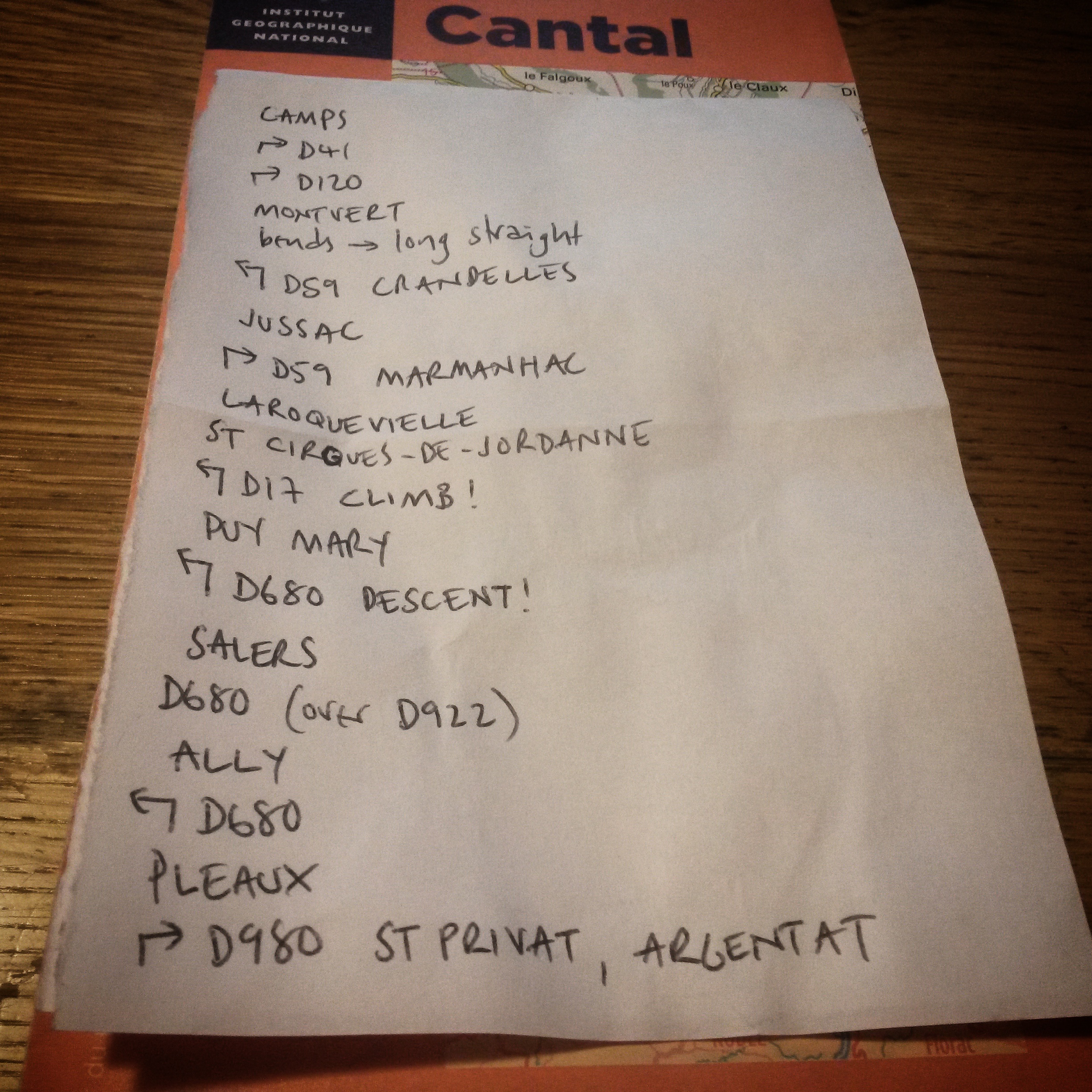
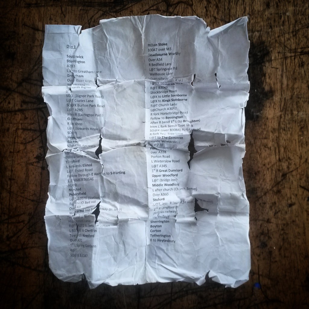
When I plotted routes previously and created a list of instructions I’ve had to trace the route in my mind, follow it on a map. The act of writing things down somehow fixed it in my head. I had an idea of where I was going, enough to sense when I may have gone off course. However following a list of instructions successfully is also based on the premise that firstly I’ve written them down correctly (I am very good at confusing left and right) and the I follow them correctly (I am very good at confusing right and left). I tend to route rides via the smallest lanes I can find on the map. This means towns and signposts are few and far between. This invariably means beautiful and quiet rides but missing an instruction, getting out of sync, sometimes finds me lost hoping my sense of direction is good enough to at least head vaguely the right way until I find something that corresponds with something on the list of places. Worst case scenario there’s always a back-up GPX file on my phone (see, I told you I wasn’t anti-technology).
With the Garmin once I’ve plotted the route I’ve probably simply downloaded it. I won’t have gone through it in my head in the same way I do with paper routes. The vagaries of online route plotting tend to try and send you across a field or down a bridleway which doesn’t appear to exist every now and again anyway. Fortunately I know this from paper lists so I know not to put all my trust in that blue line. I mustn’t be tempted to follow it blindly. Somewhere sometime it’ll be wrong.
The screen. That is the real issue. I go out on the bike to avoid screens and there I am with one attached to my stem, visible out of the corner of my eye, asking to be looked at, checked constantly. It draws the eye like a silent television across a noisy pub. It can separate me from the now. In full view it creates anxiety that a piece of paper in my pocket out of sight never did. Why when I’m riding a straight road with no junctions do I look at it to make sure that this is still the right straight road with no junctions rather look at what is around me? I have absolutely no idea and it’s a newly formed habit that needs breaking before it sets in. A list on a piece of paper may be no more meaningful that blue line but at least I take it from my pocket and hold it up in front of me, level with the view around me, check it, stick it back in my pocket. I look up not down.
I have to figure out my relationship with this little screen on my handlebars, make it work for me. I have now entered the 2017 Transcontinental Race and if I get in it is far too long to make a list of junction by junction directions, and I can’t carry maps for half of Europe. I will have to follow that blue line and hope – really hope – I plotted the right blue line.
If not I’ll find a petrol station and buy a map.


Leave a comment